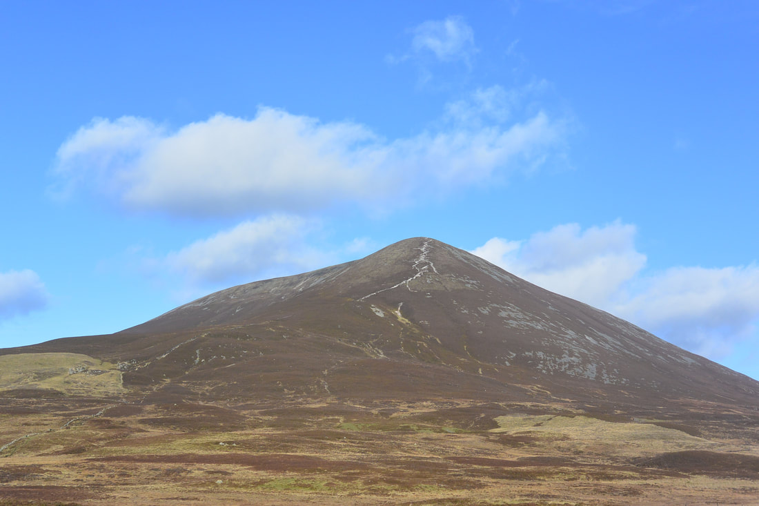
Good image showing the scarring on the upper quartzite cone with the scree flowing off to the sides.
Cairn Liath, Beinn a'Ghlo. Phase 1.
OVERVIEW.
Cairn Laith in part of the Beinn a'Ghlo range at the southern tip of the Cairngorms National Park. The scar on this quartzite mountain, which is highly visible from the A9 both north and south, has been steadily getting worse due to water rushing down from the top in heavy rain falls. It suffers from similar problems to Croagh Patrick in Ireland with it being a quartzite mountain, these environments are characterised by shallow, loose soils which once disturbed do not hold the vegetation very well, once that has gone the loose soils are quickly eroded leaving a loose quartzite base which once washed through form highly mobile scree slopes of white quartz and become very visible.
Cairn Liath was surveyed by the Outdoor Access Trust for Scotland as part of the TMTP path project and was classified as a priority 1 path, the highest level available.
Due to the sheer size of this contract, one of the largest hand build contracts ever undertaken, it was proposed a 2-3 year time frame for the main build.
The site needed to be broken down into 3 main areas of work, these coincided with the landscape and geology as it changed through the site;
1st section: This crosses a base rich upland fenland which is an extremely important habitat in Scotland with very few examples in existence. There were multiple braids all across this area as walkers try to negotiate the natural water channels that criss cross it, these channels are prone to flooding and the change can be quite dramatic and fast occurring.
Access and egress routes are quite different too as sight lines and braids make route choice difficult in both main directions of travel.
Early on in the project we spent a lot of time trying to find the best route as this was going to be the final part of the build, this was achieved in the first place by how we accessed the site ourselves but secondly and most importantly by observing hill walkers habits.
We also started to think of various solutions for the couple of potential routes we had identified, and to work out the pros and cons.
2nd Section: This section starts at the end of the old dilapidated dyke just as the path starts to ascend, the geology of this section was characterised by shist type materials and sandy soils.
Areas of this section had rare and important plant species that had to be protected and avoided and some very mobile natural landforms.
The build on this section was to be a mixture of stone pitching and aggregate surfacing with side drains.
3rd Section: The final section starts a very obvious point of the change in the geology of the mountain, namely the quartzite cone. This is where the main scarring that is visible from the A9 has occurred.
This is also the steepest section and the huge amounts of unusable loose quartzite are exposed here making walking very difficult, walkers push to the edges, break the vegetation and so loosen the fragile top soils, as water flows down the hill these are washed away and expose the quartzite underneath. Subsequent footfall then pushes this material down hill were it forms into vast plumes that extend down the mountain and outflows over the vegetation which is then killed off and the process then accelerates.
MATERIALS.
An Almost total lack of materials on the hill and strict restrictions on the scree slopes around Beinn a'Ghlo meant this had the potential to be a real issue, importing the quantities required would be a huge extra cost and a logistical nightmare.
Luckily the dilapidated dyke that follows the path line we had identified for the lower works provided a good source of materials. After checks and permissions were sought and granted fro its removal the land owner kindly agreed to its use, without this permission from them it is doubtful the project could have proceeded.
Dismantling the dyke, and then separating it into quartzite and shist for use on the various geologies of the hill was a monumental task that would need to take place every year as it was not possible to fly that much material up and just leave it for the duration of the project.